
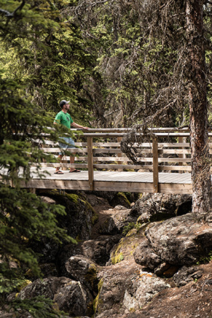
Spending time exploring a path amongst the trees, along lakes or over mountains is one of the most relaxing restful and rejuvenating experiences you can undertake to help revive mind, body and spirit. The Cariboo Chilcotin Coast offers hikers nearly unlimited opportunities to take a leisurely stroll, tackle a mountain or embark on a multi-day backcountry adventure. Simply find a trail, ensure you are prepared for wildlife, and take a respectful trek to the Land Without Limits.
Bridge Lake Ice Caves Trail | Jonny Bierman
Hike the Land of Hidden Waters
The valley and hills along Highway 24 offer myriad lakes, fishing opportunities and exceptional hikes. Here are some top hikes to consider:
- Bridge Lake Provincial Park (Various, Easy)
- Canim Lake & Mahood Falls (2.3 km/1.4 mi, Easy)
- Deception Falls Trail (Short, Easy)
- Green Lake Provincial Park (1 km/0.62 mi, Easy)
- Hendrix Creek Falls Trail (300 m/0.186 mi, Easy)
- Mount Begbie Lookout (800 m/0.5 mi, Moderate}
- Sheridan Lake (Various)
View details for hikes in a Land of Hidden Waters
Learn more about a Land of Hidden Waters
Cariboo Gold Rush Trail Hiking
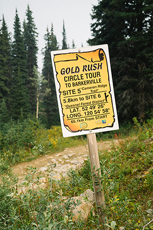
Barkerville Hiking Trails | Jonny Bierman
This history-rich region is crisscrossed with old wagon routes and trading paths, perfect for a stroll back through time that includes unique geological formations and incredible scenery. Consider the following trails:
- Big Bar Lake Provincial Park (2 km/1.2 mi, easy)
- Blackwater Canyon (3 km/1.9 mi, easy)
- Cameron Ridge Trail (14 km/ 9mi, moderate)
- Collins Overland Trail (33 km/21 mi, moderate)
- Horsefly Lake Provincial Park (various)
- Barkerville (various), including
- Groundhog Lake/Mount Agnes Trail (17 km/11 mi, moderate/etrenuous)
- Grouse Creek Trail – Barkerville to Racetrack Flats (30 km/19 mi, strenuous)
- Lowhee to Barkerville (2 km/1.2 mi, easy)
- Powderhouse Trail (30 km/19 mi, strenuous)
- Richfield Cemetery Trail (800 m/0.5 mi, easy/moderate)
- Williams Creek Loop (10 km/6 mi, moderate)
Discover more about these Cariboo Gold Rush Trail hikes.
Chilcotin Hiking Trails
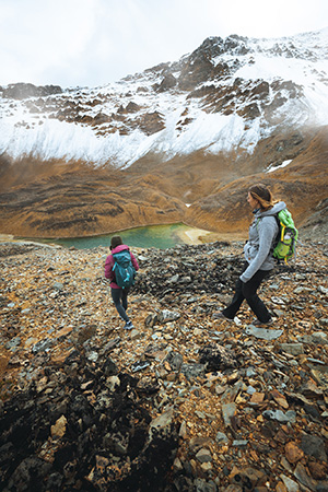
Perkins Peak, Tatla Lake | Jesaja Class
Really get away from it all with a floatplane trip to some idyllic backcountry camping and hiking, or discover a path just a few metres from the road. Mountain peaks and glacially-created plateaus permit lovely views and nearly unlimited hiking opportunities, with these trails in particular worth traversing:
- Anahim Lake
- Kappan Mountain Lookout Trail (3.6 km/2.2 mi, moderate/strenuous)
- Precipice Rimrock (Hotnarko Falls) Trail (short, easy)
- Junction Sheep Range Provincial Park (various)
- Potato Mountain Trails
- Crest Route (15 km/9 mi, moderate)
- North Potato Trail (6 km/4 mi, moderate)
- Potato Mountain Trail (9 km/6 mi, moderate)
- Puntzi Lake Trails (various, easy)
- Tatla Lake Community Trails (various, easy/moderate)
- Ts’ilʔos Provincial Park
- Tchaikazan-Yohetta Trail (4-6 days, moderate)
- Tullin Mountain Trail (12 km/7 mi, Moderate)
- Tweedsmuir Provincial Park
- Hunlen Creek & Falls (4-6 days or via floatplane, strenuous)
- Rainbow Range (Assorted, Moderate/Strenuous)
Take a stroll on Chilcotin hiking trails.
Learn more about the Chilcotin
Great Bear Rainforest Hiking Trails
Ancient petroglyphs, towering old-growth cedars and the largest coastal temperate rainforest in the world – experience it all and more by connecting with nature by exploring hiking trails in the Great Bear Rainforest. Pristine wilderness and few faces allow you to forget the outside world and reconnect with the earth in all its glory.
-
Firvale | Jen Thorpe
Bella Coola Valley
- Grey Jay Lake Trail (4 km/2.5 mi, easy/moderate)
- Clayton Falls (short, easy)
- Hagensborg Loop Trail (7 km/4 mi, moderate)
- Medby Rock Lookout Trail (2 km/1.2 mi, moderate)
- Saloompt Forest Trail (1 km/0.6 mi, easy)
- Schoolhouse Mountain Falls Trails (1.5-2km/0.9-1.2 mi, moderate/strenuous)
- Snooka Trail System – East Loop (6 km/4 mi, easy/moderate)
- Snooka Trail System – South Loop (1.7 km/1 mi , easy/moderate)
- Snooka Trail System – West Loop (3.8 km/2.4 mi one way, moderate)
- Snootli Creek Regional Park (various, easy)
- Klemtu Hiking Trails (various)
- Ocean Falls (various)
- Shearwater Hiking Trails
- Croil Lake (1.6 km/1 mi, easy/moderate)
- Eddie Lake (6 km/4 mi, moderate)
Embark on adventure on a hiking trail in the Great Bear Rainforest.
Learn more about the Great Bear Rainforest
Discover fantastic hiking trails throughout the Cariboo Chilcotin Coast, or download a travel guide to help plan your next adventure.